


La Vineuse circuit Miguel page 137

grasgilbert
User
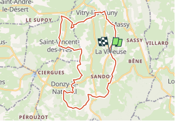

Length
19.1 km

Max alt
438 m

Uphill gradient
481 m
Km-Effort
26 km

Min alt
221 m

Downhill gradient
482 m
Boucle
Yes
Creation date :
2024-05-09 12:45:24.377
Updated on :
2024-05-09 12:55:08.445
5h48
Difficulty : Very difficult

FREE GPS app for hiking
 SityTrail
IGN / Geographical institutes
SityTrail Plus
The world is yours!
About
Trail Walking of 19.1 km to be discovered at Bourgogne-Franche-Comté, Saône-et-Loire, La Vineuse sur Fregande. This trail is proposed by grasgilbert.
Positioning
Country:
France
Region :
Bourgogne-Franche-Comté
Department/Province :
Saône-et-Loire
Municipality :
La Vineuse sur Fregande
Location:
Unknown
Start:(Dec)
Start:(UTM)
622633 ; 5147623 (31T) N.
Comments